Category:City map images that should use vector graphics
Jump to navigation
Jump to search
This is a subcategory of Category:Images that should use vector graphics. You can add images to this category using the template {{Convert to SVG|city map}}.
Media in category "City map images that should use vector graphics"
The following 200 files are in this category, out of 358 total.
(previous page) (next page)-
 000 Ivanskaya ul VN.jpg 1,000 × 1,050; 750 KB
-
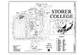 00001r Storer College Campus Map.jpg 1,024 × 683; 298 KB
-
 13 July 2011 Mumbai bombings.jpg 1,125 × 1,265; 735 KB
-
 2011 Oslo attacks map-he.jpg 401 × 346; 120 KB
-
 2012AuroraShootingLocation.png 1,518 × 2,202; 2.23 MB
-
 2013 Boston Marathon bombings map.png 887 × 819; 680 KB
-
 2016 shooting of Dallas police officers map.jpg 804 × 608; 56 KB
-
 2018 07 30 Fürstenberg KZ-Ravensbrück final 2.PNG 881 × 527; 429 KB
-
 2019 Atlanta Marathon course.png 828 × 841; 1,004 KB
-
 452px-MnpBruggeenhavenMap.jpg 452 × 459; 117 KB
-
 8thgatech.jpg 532 × 464; 73 KB
-
 A budapesti Kodály körönd épületeinek térképe.png 1,392 × 1,184; 51 KB
-
 Abbottabad Thumb.png 300 × 260; 39 KB
-
.png/120px-ACTUR_-_Rey_Fernando_(Zaragoza).png) ACTUR - Rey Fernando (Zaragoza).png 2,311 × 1,703; 1.08 MB
ACTUR - Rey Fernando (Zaragoza).png 2,311 × 1,703; 1.08 MB
-
 AdamsNE-KenesawTownship.png 350 × 355; 8 KB
-
 AIWO.png 1,206 × 1,497; 322 KB
-
 Annalee and Winni Playhouse Campus Map.jpeg 860 × 514; 27 KB
-
 Aquae planrome.PNG 1,128 × 900; 91 KB
-
 Arbat-map.png 640 × 480; 22 KB
-
 Archdiocese of Chicago Vicariate Map.png 819 × 1,079; 39 KB
-
 Arsufmap8-index.png 519 × 600; 49 KB
-
 Aspen Lake Botkyrka Municipality.png 1,201 × 787; 1.16 MB
-
 Aspendos plan of the ancient city.jpg 514 × 710; 141 KB
-
 Athens Metro by date from Wikidata.jpg 725 × 650; 75 KB
-
 Atlantic county districts.png 372 × 314; 16 KB
-
 Auburn high campus map.png 570 × 454; 88 KB
-
 Avenida de Motael.jpg 937 × 657; 77 KB
-
 Avenida Dom Ricardo da Silva.png 1,652 × 799; 1.36 MB
-
 Babylon map.png 800 × 694; 19 KB
-
 Bacia sao francisco.jpg 858 × 624; 94 KB
-
 Barnbruch Skizze.png 876 × 522; 49 KB
-
.png/120px-Barrio_de_Jesús_(Zaragoza).png) Barrio de Jesús (Zaragoza).png 2,311 × 1,703; 1.08 MB
Barrio de Jesús (Zaragoza).png 2,311 × 1,703; 1.08 MB
-
.png/120px-Barrio_Oliver_(Zaragoza).png) Barrio Oliver (Zaragoza).png 1,078 × 758; 190 KB
Barrio Oliver (Zaragoza).png 1,078 × 758; 190 KB
-
 Bayon Bridge Map.png 872 × 1,013; 923 KB
-
 Bedford centre.png 2,601 × 2,398; 1.57 MB
-
 Bedford streetmap.png 683 × 740; 65 KB
-
 Berlin hertzallee.png 691 × 524; 147 KB
-
 Berlin Lageplan High-Deck-Siedlung.png 1,677 × 1,945; 505 KB
-
 Berlin vor 1920.png 2,637 × 2,267; 345 KB
-
 Berlin-Weißensee Karte.png 631 × 521; 44 KB
-
 Berlin.bezirke.png 631 × 521; 24 KB
-
 Bhagwangarh, Bathinda, Panjab.png 2,689 × 2,246; 522 KB
-
 Blasts Mar2010 on metro map.png 790 × 778; 43 KB
-
 Bloomsbury - map 1.png 640 × 580; 113 KB
-
 BOE.png 1,209 × 1,497; 235 KB
-
 Bogota location map.png 1,699 × 2,326; 2.72 MB
-
 Boithre Luimnigh.jpg 1,740 × 1,502; 194 KB
-
 Bonn Stadtbezirke.png 200 × 241; 7 KB
-
 Bordeaux Boulevards.png 812 × 844; 202 KB
-
 Borne 52 - Allemagne-Luxembourg-Belgique.jpg 650 × 660; 59 KB
-
 Boundaries of Skärholmen within City of Stockholm.png 806 × 764; 29 KB
-
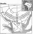 Brasília, Brasil.jpg 1,079 × 1,103; 77 KB
-
 Bratislava.20080908.png 907 × 973; 492 KB
-
 Brisbane map of city cbd.PNG 1,116 × 1,246; 322 KB
-
 Brisbane map of city cbd.png 1,116 × 1,246; 161 KB
-
 Brisbane OpenStreetMap.png 627 × 671; 279 KB
-
 Brisbane southbrisbane.png 871 × 598; 339 KB
-
 Brockenkuppe wp.png 1,831 × 1,280; 320 KB
-
 Bronowice2xx12.PNG 427 × 338; 12 KB
-
 Bronowicexx11.PNG 432 × 349; 12 KB
-
 Bronxpoverty.JPG 550 × 595; 212 KB
-
 Bronxrace.PNG 745 × 549; 416 KB
-
 Budapest districts.png 531 × 510; 41 KB
-
 Bundeshaus map.jpg 1,976 × 1,482; 888 KB
-
 Burgos de Pamplona.png 1,150 × 850; 842 KB
-
 Campus plan, RIT NandE Vol17Num19 1986 Jul17 Complete.jpg 1,364 × 1,081; 252 KB
-
.jpg/98px-CampusMap2011(0).jpg) CampusMap2011(0).jpg 680 × 829; 520 KB
CampusMap2011(0).jpg 680 × 829; 520 KB
-
 CampWashington.PNG 552 × 373; 42 KB
-
 CAMY ROLLEBOISE.png 1,279 × 791; 87 KB
-
 Canalvc.png 500 × 459; 73 KB
-
 CapitolComplexMap.jpg 520 × 740; 130 KB
-
 Cardiff city centre basic map.jpg 815 × 529; 63 KB
-
 Carlton Bedfordshire map.png 408 × 345; 23 KB
-
 Carnuntum map Roman city.png 1,613 × 1,157; 72 KB
-
 Carte des zones saint etienne métropole.jpg 604 × 408; 53 KB
-
 Carte géolocalisation Grenoble.png 703 × 794; 979 KB
-
 Carthage-Cincinnati-map.jpg 1,332 × 844; 408 KB
-
 Carthage.png 355 × 410; 6 KB
-
 Cartina Cecchina e zone.jpg 2,300 × 1,486; 414 KB
-
 Case.png 800 × 661; 159 KB
-
 CasernesVigile planrome.png 1,128 × 900; 53 KB
-
 CCIN.jpg 325 × 347; 82 KB
-
 Central Ottawa.PNG 696 × 631; 26 KB
-
 Central Vila Verde.png 1,281 × 1,506; 499 KB
-
 Central Washington University Map.jpg 4,200 × 2,550; 1.35 MB
-
 Changzhou map.png 543 × 310; 7 KB
-
 Charite - Universitaetsmedizin Berlin - locations.JPG 484 × 395; 29 KB
-
 Charlestown Map.png 947 × 645; 18 KB
-
.png/116px-Chase_Center%2C_San_Francisco_–_Map%2C_April_2016_(zoom).png) Chase Center, San Francisco – Map, April 2016 (zoom).png 1,189 × 1,235; 532 KB
Chase Center, San Francisco – Map, April 2016 (zoom).png 1,189 × 1,235; 532 KB
-
 Chateau-tuileries.jpg 707 × 467; 152 KB
-
 Chemnitz-Fritz-Heckert-Gebiet.jpg 761 × 600; 79 KB
-
 ChennaiMasterplan.png 1,200 × 1,451; 155 KB
-
 Chicago 1927 mayor by ward.png 683 × 652; 46 KB
-
 Chicago locator map.png 615 × 647; 406 KB
-
 Chicago violent crime map 2006.png 1,730 × 3,008; 739 KB
-
 China Sex Museum map.png 320 × 287; 11 KB
-
.gif/112px-CIA_World_Factbook_map_of_Singapore_(English).gif) CIA World Factbook map of Singapore (English).gif 329 × 352; 19 KB
CIA World Factbook map of Singapore (English).gif 329 × 352; 19 KB
-
.png/112px-CIA_World_Factbook_map_of_Singapore_(English).png) CIA World Factbook map of Singapore (English).png 327 × 350; 15 KB
CIA World Factbook map of Singapore (English).png 327 × 350; 15 KB
-
 Cincinnati Transit Frequency Map.png 3,000 × 2,347; 1.74 MB
-
 Cities and municipalities of the Philippines.png 4,751 × 6,104; 2.01 MB
-
 City of Carthage circa 149 BC.png 1,371 × 1,096; 196 KB
-
 City of Novi Sad 1.PNG 1,568 × 1,243; 68 KB
-
 City Park neighborhood in Denver.jpg 729 × 541; 183 KB
-
 City plan 1942.jpg 1,232 × 1,275; 510 KB
-
 Citygardenmap.png 924 × 737; 223 KB
-
 CivicRoomMap.png 918 × 720; 177 KB
-
 Civilcourtsbuildingmap.png 937 × 729; 213 KB
-
 CobhamMap.png 1,017 × 774; 322 KB
-
 Coedarhydyglyn.png 1,049 × 762; 554 KB
-
 Constantinople imperial district.png 717 × 812; 236 KB
-
 Constantinople map Polish-2.PNG 995 × 1,279; 182 KB
-
 Constantinople PL.png 800 × 650; 14 KB
-
 Constantinople.png 800 × 650; 55 KB
-
 Craighousemap.jpg 2,550 × 2,503; 545 KB
-
 Culverhouse Cross map.png 1,178 × 792; 382 KB
-
 Daingean.png 1,166 × 1,136; 181 KB
-
 Danforthcampus.png 765 × 559; 143 KB
-
 Dare, Fatunaba and Nahaec.png 1,081 × 860; 209 KB
-
 Deltonaflua.png 575 × 425; 41 KB
-
 DENIGOMODU.png 1,420 × 1,104; 274 KB
-
 Denver neighborhoods.gif 729 × 541; 13 KB
-
 Detailed map of Benson, Arizona.png 575 × 425; 24 KB
-
 DeVilbissCampus.PNG 516 × 453; 12 KB
-
 Disneyland Resort Paris - Plattegrond.PNG 650 × 656; 39 KB
-
 DLRP schema.png 650 × 656; 43 KB
-
 Docklands-map.jpg 490 × 224; 22 KB
-
 Downtown Ottawa.png 592 × 453; 193 KB
-
 DowntownRichmondNeighborhoods.jpg 659 × 564; 104 KB
-
 Dresden Center Sehenswuerdigkeiten.png 3,004 × 2,267; 4.63 MB
-
 Drury Lane map.png 427 × 270; 130 KB
-
 Early settlements in LuxbrgCity-english.jpg 937 × 1,422; 300 KB
-
 Einzugsbereich des Geschwister-Scholl-Gymnasiums in Daun.jpg 1,491 × 1,540; 720 KB
-
 Elbeuf map nk.png 883 × 593; 61 KB
-
 Electorate Perth 2005 2009.png 200 × 210; 17 KB
-
 Emona in ljubljana osm.jpg 781 × 785; 507 KB
-
 Emplacement tour Eiffel 7e arrondissement.JPG 993 × 750; 134 KB
-
 Entwicklungsgebiet Alter Schlachthof.png 1,071 × 883; 788 KB
-
 Estrecho mapa.JPG 1,214 × 647; 168 KB
-
 F-hoechst-planinnenstadt.png 1,500 × 1,167; 2.02 MB
-
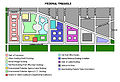 FederalTriangle WashingtonDC 2009.jpg 1,480 × 1,010; 524 KB
-
 Fire thumb tuesday.png 400 × 197; 27 KB
-
 Flint Cultural Center.pdf 1,650 × 1,275; 218 KB
-
 Foret-faisanderie-aujourdhui.jpg 1,632 × 703; 498 KB
-
 Fort Lauderdale–Hollywood International Airport via OpenStreetMap.png 1,359 × 709; 190 KB
-
 Fort Myers.gif 575 × 425; 44 KB
-
 Fort Poestlingberg 01.png 800 × 688; 75 KB
-
 Forum Romanum um 200.jpg 2,953 × 2,461; 440 KB
-
 Fotostandorte Horsetail Fall.png 583 × 279; 156 KB
-
 FremantlePrisonMainCellBlockMap.jpg 1,502 × 860; 145 KB
-
 Gatewayonemap.png 928 × 738; 229 KB
-
 GHMC NEW ZONES,CIRCLE MAP.jpg 2,893 × 2,047; 2.64 MB
-
 GHMC ZONES MAP 2016.jpg 402 × 366; 31 KB
-
 GianonewplanQueluz.JPG 869 × 953; 96 KB
-
 Gibraltar roads 1.png 861 × 945; 266 KB
-
 Gibraltar roads2.png 527 × 897; 219 KB
-
 Gibraltar roads3.png 1,499 × 902; 442 KB
-
 Gibraltar roads4.png 1,363 × 905; 452 KB
-
 Gibraltar roads5.png 1,426 × 922; 421 KB
-
 Gower Street map.png 273 × 346; 97 KB
-
 Grabenaltneu.png 905 × 511; 80 KB
-
 Gray's Inn Road - map 1.png 360 × 540; 198 KB
-
 Great fire of london map.png 2,549 × 1,612; 3.61 MB
-
 Great Fire of London Map.png 2,550 × 1,500; 342 KB
-
 Great-Kazan-ring.jpg 1,027 × 1,047; 332 KB
-
 Greater Mexico City.JPG 381 × 383; 85 KB
-
.jpg/90px-Grundriss_der_Residenz_München_(Bayerische_Schlösserverwaltung).jpg) Grundriss der Residenz München (Bayerische Schlösserverwaltung).jpg 1,156 × 1,532; 1.21 MB
Grundriss der Residenz München (Bayerische Schlösserverwaltung).jpg 1,156 × 1,532; 1.21 MB
-
 Grüner See Falk Oberdorf1.jpg 1,664 × 1,035; 396 KB
-
 Gwaliorfort.png 1,911 × 1,064; 189 KB
-
 HagatnaMap.PNG 2,303 × 1,127; 566 KB
-
 Hannover Stadtgliederung.png 1,000 × 779; 202 KB
-
 Harrisburg IL public square 1953.jpg 797 × 768; 71 KB
-
 HE-Leptis Magna.png 800 × 686; 22 KB
-
 Hebron redeployment 1997.jpg 1,326 × 1,428; 275 KB
-
 Heilbronn map closer.gif 860 × 875; 84 KB
-
 HeilbronnLandkarte.png 1,134 × 840; 83 KB
-
 Hiddenhausen-Admin.png 260 × 241; 24 KB
-
 HOD1.png 936 × 504; 6 KB
-
 Hoybraten map.png 1,942 × 968; 646 KB
-
 Hydro nantes.png 1,417 × 1,361; 161 KB
-
 Hägersten osm 20110413 001.png 1,665 × 1,284; 1,014 KB
-
 IffleyVillageMap.png 504 × 454; 128 KB
-
 Image-Qingdao city map 1912 in german.png 1,585 × 1,184; 961 KB
-
 Inner-canberra 01MJC.png 1,100 × 1,200; 146 KB
-
 Jerusalem map.jpg 348 × 348; 50 KB
-
 Jerusalem Muslim Quarter map-HE.jpg 593 × 794; 75 KB
-
 Jerusalem Muslim Quarter map.jpg 659 × 891; 66 KB
-
 Kalvø.png 548 × 814; 307 KB
-
 Kamakura-Map Final.png 1,104 × 1,304; 88 KB
-
 Karta ChichenItza.PNG 555 × 520; 31 KB
-
 Karta Jerash.PNG 680 × 480; 20 KB
-
 Karta Karthago.PNG 555 × 520; 18 KB
-
 Karte berlin akzisemauer.png 1,200 × 864; 337 KB
-
 Karte berlin auswaertigesamt.png 1,200 × 1,209; 409 KB
-
 Karte Berlin Landnutzung.png 10,361 × 8,336; 21.98 MB
-
 Karte Eiswerder.png 1,023 × 669; 49 KB
-
 Karte Kapellenberg.png 1,942 × 2,246; 3.01 MB
-
 Karte memmingen3 altstadt.jpg 1,100 × 1,266; 268 KB
-
 Karte2 Spreebogen.JPG 380 × 418; 31 KB
-
 KarteKrummhoern.png 1,200 × 1,649; 571 KB
-
 Kazan-Tatar-map.png 1,366 × 661; 415 KB


.png)


.png)
.png)


.jpg)


.png)


.gif)
.png)


.jpg)


