Category:Geology images that should use vector graphics
Jump to navigation
Jump to search
This is a subcategory of Category:Images that should use vector graphics. You can add images to this category using the template {{Convert to SVG|geology}}.
Media in category "Geology images that should use vector graphics"
The following 200 files are in this category, out of 343 total.
(previous page) (next page)-
 1920 Gansu earthquake.png 705 × 599; 176 KB
-
 1970 Tonghai earthquake.png 214 × 156; 25 KB
-
 1976 Tangshan.png 705 × 599; 169 KB
-
 1985 Wuqia earthquake.png 251 × 198; 34 KB
-
 1999Chamoli.png 179 × 159; 19 KB
-
 2008TC3-groundpath-rev.png 537 × 579; 232 KB
-
 2008TC3-groundpath.png 329 × 352; 93 KB
-
 2010 Serbia earthquake — 4.jpg 612 × 684; 228 KB
-
 2015-06-15 Erdbeben in Nepal.jpg 1,123 × 794; 114 KB
-
 2016 Ecuador earthquake-IGEPN20160417a-6.jpg 896 × 1,268; 294 KB
-
 20191021 Temperature from 20,000 to 10,000 years ago - recovery from ice age.png 2,572 × 1,948; 101 KB
-
 250.00 Million year in the Future-Pangaea Proxima.jpg 948 × 487; 24 KB
-
 500vc ex leg Arabic.jpg 510 × 786; 336 KB
-
 5500vc ex leg Arabic.jpg 510 × 786; 376 KB
-
.jpg/120px-A_1908_Fig_16_Lobes_of_Retreating_Ice_(Mich).jpg) A 1908 Fig 16 Lobes of Retreating Ice (Mich).jpg 1,517 × 990; 98 KB
A 1908 Fig 16 Lobes of Retreating Ice (Mich).jpg 1,517 × 990; 98 KB
-
 Accretion-Subduction.PNG 751 × 388; 67 KB
-
 Adour-en.png 592 × 440; 212 KB
-
 Advancing ramp in incompetent layers.PNG 573 × 695; 235 KB
-
 Aerosol dimming.jpg 500 × 207; 11 KB
-
 African plate.PNG 1,134 × 1,134; 231 KB
-
 AfriqueStressHydrique2025.jpg 612 × 526; 79 KB
-
 Alignment.001.png 800 × 600; 239 KB
-
 Alpengeologie01.png 3,144 × 1,513; 2.56 MB
-
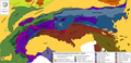
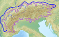
 Alps geology map.jpg 3,338 × 1,607; 1.84 MB
-
 Amazon river basin.png 434 × 366; 46 KB
-
 Amazonasbecken.png 434 × 366; 27 KB
-
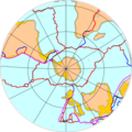 Antarctic plate.png 1,134 × 1,134; 211 KB
-
 Antarctic shelf ice hg.png 2,834 × 1,749; 196 KB
-
 Appalachian orogeny.jpg 432 × 583; 107 KB
-
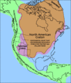
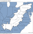 Appalachian region of United States.png 570 × 585; 56 KB
-
 Aquifère Darcy échanges flux.jpg 1,131 × 1,524; 165 KB
-
 Aquifère Darcy échanges nappe.jpg 1,366 × 768; 148 KB
-
 Aquifère Darcy échanges variant sédiment.jpg 1,366 × 1,568; 182 KB
-
 Aquifère Darcy échanges.jpg 1,366 × 1,568; 170 KB
-
 Arctic profile hg.png 1,114 × 560; 147 KB
-
 Argentina hydrographic map.png 321 × 529; 29 KB
-
 Arsenic contamination areas.jpg 650 × 370; 64 KB
-
 Atlas Mountains tectonic plates.png 175 × 108; 11 KB
-
 Atoll forming.jpg 283 × 503; 21 KB
-
 Ausgeolbasic.jpg 918 × 845; 129 KB
-
 Australian plate.PNG 1,134 × 1,134; 226 KB
-
 Balance hidrico.jpg 940 × 304; 75 KB
-
 Bankuai.png 8,300 × 5,664; 10.94 MB
-
 Barchan dune.jpg 513 × 285; 30 KB
-
 BBC-strat-date-.jpg 1,488 × 1,666; 105 KB
-
 Beach classification.JPG 665 × 528; 47 KB
-
 Bedforms under various flow regimes.pdf 1,183 × 822; 23 KB
-
 Biostuoia.jpg 199 × 199; 17 KB
-
 Blattverschiebung.jpg 369 × 301; 12 KB
-
 Bowen.jpg 496 × 352; 18 KB
-
 Bravo RAND Corp.JPG 855 × 530; 62 KB
-
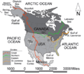
 Canada geological map-WCSB.JPG 2,000 × 1,557; 2.07 MB
-
 Canada geological map.JPG 2,000 × 1,557; 2.25 MB
-
 CARNIAN EARTH.jpg 720 × 540; 126 KB
-
 Carte de la dorsale en Islande.png 376 × 390; 8 KB
-
 Cascadia subduction zone USGS.png 495 × 706; 23 KB
-
 Casing Diameters of a Borehole.JPG 526 × 719; 39 KB
-
 Caspianseamap.png 600 × 602; 196 KB
-
 Catena of soils.jpg 960 × 720; 40 KB
-
 Charlesrivermap.png 1,000 × 1,000; 587 KB
-
 Chemoclines.png 408 × 256; 16 KB
-
 Chernozem distribution.JPG 500 × 351; 21 KB
-
 Chesapeake Bay impact crater4.jpg 640 × 507; 60 KB
-
 Chesapeake Crater boundaries map.png 440 × 401; 33 KB
-
 Chesapeake Crater profile view.png 474 × 333; 22 KB
-
 Chile provinces earthquake dead.png 3,236 × 3,512; 516 KB
-
 CHN povodi rek.PNG 380 × 295; 10 KB
-
 Climatic zones and antipodes.png 180 × 180; 31 KB
-
 CO Mineral Belt.jpg 453 × 321; 35 KB
-
 Continental shelf fr.png 456 × 180; 5 KB
-
 Continental shelf german.png 1,080 × 381; 32 KB
-
 Continental shelf ita.png 456 × 180; 15 KB
-
 Continuous spaced cleavage.jpg 700 × 288; 21 KB
-
 Coral reef locations.jpg 640 × 224; 81 KB
-
 Crete 365 uplift.png 1,525 × 1,613; 519 KB
-
 Croquis estuaire Seine.png 1,700 × 1,500; 67 KB
-
 Cross section of mariana trench.jpg 600 × 319; 99 KB
-
 Crust formation age distribution.JPG 747 × 707; 44 KB
-
.jpg/85px-Current_flow_(9250137832).jpg) Current flow (9250137832).jpg 1,500 × 2,103; 363 KB
Current flow (9250137832).jpg 1,500 × 2,103; 363 KB
-
 Cycle de l'eau.png 1,043 × 562; 245 KB
-
 Cylindrical fold.PNG 703 × 591; 281 KB
-
 CZE geomorf.PNG 900 × 670; 81 KB
-
 Delta sezione longitudinale.png 905 × 623; 14 KB
-
 Derwent Map.JPG 1,932 × 2,065; 1.24 MB
-
 Drivers, Processes, and Impacts of Sinking Cities.png 2,467 × 1,353; 107 KB
-
 Dune2.png 758 × 532; 70 KB
-
 Earth temperature.PNG 1,102 × 737; 86 KB
-
 Earth-crust-cutaway.png 427 × 333; 84 KB
-
 Earthquake FW-HW Diagram.jpg 376 × 265; 63 KB
-
 Earthquake severity.jpg 719 × 501; 109 KB
-
 Earthquake wave paths in Chinese.png 2,000 × 1,667; 259 KB
-
 Earthquake wave paths SK.png 585 × 495; 32 KB
-
-
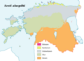 Eesti pealiskord.png 848 × 614; 50 KB
-
 Eldfell eruption diagram.png 486 × 463; 70 KB
-
 Erdbeben in Osttimor.png 967 × 527; 20 KB
-
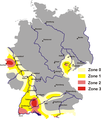 Erdbebenzonen.png 1,902 × 2,248; 144 KB
-
 Eurasian plate.PNG 1,134 × 1,134; 251 KB
-
 Europäische Wasserscheiden - Zoom auf Pass Lunghin.png 1,200 × 1,184; 700 KB
-
 Europäische Wasserscheiden.png 1,200 × 1,184; 526 KB
-
.jpg/120px-Evolution_of_temperature_in_the_Post-Glacial_period_according_to_Greenland_ice_cores_(Younger_Dryas).jpg)
-
 Eyjafjallajökull volcanic ash 17 April 2010.png 680 × 520; 127 KB
-
 Falk Oberdorf Wiehengebirge Gliederung.png 960 × 511; 81 KB
-
 Falk Oberdorf Wiehengebirge physisch.png 1,547 × 844; 961 KB
-
 Falla.png 547 × 163; 2 KB
-
 Fault block mountain.JPG 668 × 432; 37 KB
-
 Faultbendfold.png 1,052 × 744; 34 KB
-
 Feliform-Timeline.jpg 549 × 550; 52 KB
-
 Fjord some eng text.jpg 1,274 × 684; 427 KB
-
 FK3LMB.jpg 221 × 207; 22 KB
-
 Flank & hinge.PNG 1,019 × 823; 359 KB
-
 Florida Current map.jpg 600 × 418; 40 KB
-
.png/120px-Formation_of_passive_margins_(horizontal).png) Formation of passive margins (horizontal).png 2,366 × 314; 36 KB
Formation of passive margins (horizontal).png 2,366 × 314; 36 KB
-
 Formation of passive margins.png 1,202 × 1,144; 74 KB
-
 Friendly Floatees.png 850 × 523; 56 KB
-
 Ga geologic regions.gif 300 × 351; 4 KB
-
 GB-Definition-Map.jpg 286 × 392; 17 KB
-
 Geo land2.PNG 1,214 × 1,514; 74 KB
-
 Geologic map of Crater Lake floor.png 477 × 544; 12 KB
-
 Geologic with plates.png 402 × 590; 73 KB
-
 Geologische Karte Lahnmulde.png 2,903 × 2,542; 1.5 MB
-
 Geologisk tid 01.jpg 375 × 301; 26 KB
-
 Geomorphology of Old River.jpg 959 × 847; 153 KB
-
 Geothermal gradient.png 2,160 × 1,476; 1.25 MB
-
 Geothermal resource map US.png 503 × 280; 28 KB
-
 Gerilemis buzul cephesi.png 442 × 214; 39 KB
-
 Geysir 02 without inscription.png 534 × 479; 52 KB
-
 Geysir 02.png 600 × 538; 66 KB
-
 Glacial effect hg.png 2,000 × 1,373; 1.64 MB
-
 Gondbreak.png 514 × 343; 13 KB
-
 Gondwana breakup.png 659 × 873; 149 KB
-
 Gradierte Schichtung EN.jpg 1,364 × 746; 231 KB
-
 Grafico basalti.png 700 × 500; 22 KB
-
 GraphCoastalStructuresScotland.gif 414 × 487; 86 KB
-
 Gravity, geoid anomaly synthetic cases with local isostasy 2.gif 2,202 × 1,132; 85 KB
-
 Greenland sulfate.png 394 × 557; 23 KB
-
 Grundriss Binghöhle bei Streitberg.png 1,114 × 439; 22 KB
-
 Guaviarerivermap.png 981 × 984; 164 KB
-
 Gunzenheimer Gump Systemskizze der Entstehung.jpg 730 × 1,619; 674 KB
-
.jpg/85px-Historic_flow_(9247354321).jpg) Historic flow (9247354321).jpg 1,500 × 2,103; 331 KB
Historic flow (9247354321).jpg 1,500 × 2,103; 331 KB
-
 Holocene Sea Level.png 512 × 364; 22 KB
-
 Horst graben2.jpg 300 × 225; 9 KB
-
 Hotspots.jpg 2,445 × 1,882; 1.32 MB
-
 IBM-Locality.jpg 259 × 556; 46 KB
-
 IBRA 6.1 Great Victoria Desert.png 1,257 × 986; 83 KB
-
 Ice-floe params hg.png 2,800 × 1,373; 115 KB
-
 IGRF 2000 magnetic declination.gif 1,010 × 804; 66 KB
-
 Impactcraterformation lmb.png 469 × 449; 32 KB
-
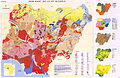
 India-geology-map.png 300 × 352; 32 KB
-
 Iraq marshes 1994.jpg 1,296 × 1,296; 215 KB
-
 Java-stratigraphy.JPG 1,301 × 861; 327 KB
-
 Jeanne dArc Basin.jpg 820 × 521; 58 KB
-
 Karlu Karlu Creation 1.png 300 × 200; 7 KB
-
 Karte von Sunda und Sahul.png 1,111 × 1,007; 208 KB
-
 Keresztirányú dűne.PNG 784 × 359; 12 KB
-
 Kilauea Cross section he.jpg 700 × 351; 41 KB
-
 Kreislauf der gesteine.png 400 × 435; 18 KB
-
 Kuunga2.png 1,150 × 920; 153 KB
-
 Laamade nimed.png 991 × 675; 98 KB
-
 Lakes scheme CZ.png 598 × 616; 26 KB
-
 Lakes scheme.png 598 × 616; 32 KB
-
 Lange diercke sachsen dresden boden.jpg 1,276 × 990; 816 KB
-
 Large eruptions.jpg 1,236 × 1,155; 193 KB
-
 Levee at Cairo.jpg 1,200 × 706; 80 KB
-
 Lithostratigraphie Saar-Nahe-Becken.jpg 659 × 1,558; 108 KB
-
 Littoral Zones.jpg 666 × 292; 35 KB
-
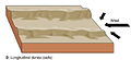 Longitudinal dune.jpg 596 × 275; 33 KB
-
 Love wave in Chinese.png 2,000 × 1,464; 466 KB
-
 Mantel bagian atas.jpg 604 × 331; 45 KB
-
 Map indonesia volcanoes.gif 731 × 410; 25 KB
-
 Map mexico volcanoes.gif 715 × 368; 14 KB
-
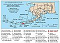
 Map of Alaska Volcanoes 1.gif 375 × 395; 117 KB
-
 Map of alaska volcanoes okmok.jpg 640 × 456; 226 KB
-
 Map of Alpine Glaciations.png 1,026 × 657; 1.43 MB
-
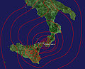 Mappa terremoto 1908.jpg 1,415 × 1,149; 400 KB
-
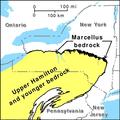 Marcellus Bedrock.pdf 900 × 900; 74 KB
-
 Marskern.jpg 178 × 169; 6 KB
-
 Mid-ocean ridge cut away view.png 1,405 × 480; 77 KB
-
 Mount Mazama eruption timeline.PNG 250 × 841; 187 KB
-
 Multiple.png 598 × 267; 10 KB
-
 Muranska planina.png 1,660 × 845; 62 KB
-
 Nankai Trough location map.jpg 626 × 493; 43 KB
-
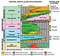
 Natuna-stratigraphy.JPG 953 × 666; 109 KB
-
 Niagara-Profil.PNG 800 × 405; 19 KB
-
 Nias-simeulue-stratigraphy.jpg 599 × 1,071; 161 KB
-
 Niger river map-PN-W.png 543 × 443; 45 KB
-
 Nigeria dominant soils.jpg 10,234 × 6,678; 17.78 MB
-
 NMO General stratigraphy hebrew.jpg 1,094 × 308; 183 KB
-
 Nor rev.png 414 × 250; 7 KB
-
 Normale Verwerfung.jpg 345 × 307; 11 KB
-
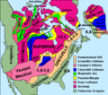 North america basement rocks.png 484 × 429; 31 KB
-
 North america craton nps.gif 512 × 599; 32 KB
-
 North American plate.PNG 1,134 × 1,134; 240 KB
-
 North German Basin Stratigraphy Column.jpg 370 × 879; 99 KB
-
 North German Basin Stratigraphy.jpg 768 × 879; 104 KB
-
 North Slope Stratigraphy.jpg 579 × 537; 418 KB
-
 NorthAmericaDivides.gif 540 × 481; 56 KB
-
 Nutrient-cycle hg.png 800 × 558; 273 KB
-
 Occludedfront.gif 574 × 256; 26 KB
-
 October 2010 Sumatra Earthquake.png 757 × 741; 379 KB


.jpg)


.jpg)


.jpg)


.jpg)
.png)