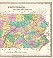
File:1827 Finley Map of Eastern Pennsylvania, en-antd Lehigh-Susquehanna & Susquehanna-Tioga Turnpike.jpg

Original file (1,850 × 2,032 pixels, file size: 2.02 MB, MIME type: image/jpeg)
Captions
Captions
Summary[edit]
| Description1827 Finley Map of Eastern Pennsylvania, en-antd Lehigh-Susquehanna & Susquehanna-Tioga Turnpike.jpg |
English: This 1827 map of Eastern Pennsylvania is filled with traces delineating the wagon road network built up in the early Canal Age. Emphasized, are the Lehigh & Susquehanna Turnpike (1804) and the Susquehanna & Tioga Turnpike (1806) which would by design (intent) of the latter's founders, eventually connect Philadelphia's manufacturies to the Great Lakes via Tioga County, Pennsylvania and Tioga, NY, Elmira, New York. |
|||
| Date | ||||
| Source | File:1827 Finley Map of Pennsylvania - Geographicus - Pennsylvania-finley-1827.jpg | |||
| Author | Anthony Finley, edited by User: Fabartus | |||
| Permission (Reusing this file) |
|
|||
| Other versions |
|
Licensing[edit]
| Anthony Finley: Pennsylvania.
( |
||||||||||||||
|---|---|---|---|---|---|---|---|---|---|---|---|---|---|---|
| Artist |
artist QS:P170,Q18507773 |
|||||||||||||
| Title |
Pennsylvania. |
|||||||||||||
| Description |
English: Derived of Finley's important 1827 map of Pennsylvania. Depicts the state with moderate detail in Finley's classic minimalist style. Shows river ways, roads, canals, and some topographical features. Offers color coding at the county level. Title at top center. Scale at bottom center.
|
|||||||||||||
| Date | 1827 (undated) | |||||||||||||
| Dimensions |
height: 9 in (22.8 cm); width: 11.5 in (29.2 cm) dimensions QS:P2048,9U218593 dimensions QS:P2049,11.5U218593 |
|||||||||||||
| Accession number |
Geographicus link: Pennsylvania-finley-1827 |
|||||||||||||
| Source/Photographer |
Finley, Anthony, A New General Altas, Comprising a Complete Set of Maps, representing the Grand Divisions of the Globe, Together with the several Empires, Kingdoms and States in the World; Compiled from the Best Authorities, and corrected by the Most Recent Discoveries, Philadelphia, 1827.
|
|||||||||||||
| Permission (Reusing this file) |
|
|||||||||||||
| Other versions |
 |
|||||||||||||
File history
Click on a date/time to view the file as it appeared at that time.
| Date/Time | Thumbnail | Dimensions | User | Comment | |
|---|---|---|---|---|---|
| current | 17:56, 16 December 2016 |  | 1,850 × 2,032 (2.02 MB) | Fabartus (talk | contribs) | User created page with UploadWizard |
You cannot overwrite this file.
File usage on Commons
The following 2 pages use this file:
Metadata
This file contains additional information such as Exif metadata which may have been added by the digital camera, scanner, or software program used to create or digitize it. If the file has been modified from its original state, some details such as the timestamp may not fully reflect those of the original file. The timestamp is only as accurate as the clock in the camera, and it may be completely wrong.
| JPEG file comment | File source: https://commons.wikimedia.org/wiki/File:1827_Finley_Map_of_Pennsylvania_-_Geographicus_-_Pennsylvania-finley-1827.jpg |
|---|---|
| Orientation | Normal |